


Trimble Access Field Software | Survey, Stakeout & 3D Scanning Tools
Trimble Access
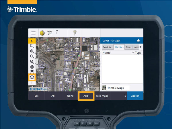
Trimble Access field software offers streamlined workflows and a comprehensive toolset for land surveyors to conduct topographic surveys, stakeouts, 3D scanning, site calibrations, and more. Compatible with both Windows® and Android™ devices, it supports seamless integration across GNSS receivers and total stations, empowering surveyors to combine conventional survey data, scanning, and GNSS data in a single project. The inclusion of Trimble Sync Manager further enhances connectivity between field and office, making data sharing effortless.
Flexible Licensing Options to Suit Your Needs
Subscription Plans: Stay up to date effortlessly with the latest features and updates automatically included. Subscriptions are user-centric, offering flexibility and scalability as your needs grow.
Perpetual Licensing: Make a one-time purchase for a permanent license tied directly to your hardware or software. Please note, perpetual licenses do not include future updates but provide long-term ownership without ongoing fees.
Purpose-Built Module Options Streamline And Simplify Field Operations
Trimble Access Roads software defines, surveys and reports on roads with a simple, easy-to-use graphical interface specific to standard roading operations.
- Upload an existing road definition. Supported file types are RXL, LandXML, 12da, and GENIO files.
- Key in an RXL road definition including horizontal and vertical alignments, templates, and superelevation and widening records.
- Review the road definition in 3D.
- Stake out the road to the road, string, a station on a string, the nearest string, or a side slope. You can also apply construction offsets.
- Generate a report for the staked road data to check in the field, or to transfer data from the field to your client or office.
Trimble Access Pipelines field software is used to collect pipe attribute data, record relationships between welds and pipes (joints), and when the pipeline is surveyed, link the join attributes to the measured welds.
- Records pipe attributes and weld relationships, linking joint attributes to surveyed welds for a complete data set.
- Allows multiple survey crews to merge and share data efficiently, supporting as-built surveys.
- Captures and records precise joint attributes related to welds.
- Generates automated and custom reports, performs validation checks, and outputs tailored data insights.
- Ensures high standards of data organization and control throughout the pipeline lifecycle
Trimble Access Tunnels software includes powerful tools to define, survey, and report your tunnel. The easy-to-use interface guides you through marking areas of underbreak and overbreak and positioning machinery.
Define your tunnel
- Define tunnel components including horizontal and vertical alignments, templates, and rotation, or import a definition from a LandXML file.
- Define end face blast holes and set out positions typically used for bolt holes. Review the tunnel before going underground.
Survey your tunnel
- Auto scan cross sections including options to manually measure and delete points.
- Measure positions relative to the tunnel definition.
- Set out predefined positions.
- Position machinery, typically a drilling rig, relative to the tunnel.
Output and reports
- Review auto scanned and manually measured points.
- Review set out points.
Trimble Access Mines field software includes powerful tools to survey and report on mine operations. The easy-to-use interface guides you through auto staking lines to position a drilling rig within a mine.
- Define and auto stake center, grade, and laser lines to align a drilling rig.
- Auto stake predefined blast hole positions.
- Auto stake predefined pivot points to position a drilling rig.
- Generate reports for the surveyed mine.
Trimble Access Monitoring software provides a streamlined workflow for repeatable total station measurements common in deformation monitoring and precise control workflows.
- Easily set up a station.
- Measure the backsight and all foresight targets and save their details to the job for subsequent site visits.
- Define the measurement parameters such as epoch interval and tolerance.
- View reports of movement above the specified tolerance – there is no need for major analysis in the field.
- View information on the measurement epoch while still in the field and then output reports that compare known coordinates with measurements over time.