|
|
Geospatial Newsletter — March 2026
|
|
|
|
Updates, news, and savings at a glance.
|
Highlights this month: software & firmware updates, industry news, and last chance savings for surveying & geospatial teams.
|
|
|
|
Software & Firmware Updates
|
|
|
|
Trade in your current perpetual TBC license or a third-party survey software
|
As Trimble continues to invest in new cloud-connected and subscription-only features, TBC is moving to a subscription-only model.
To help you make the move to the new, more powerful TBC experience, we are offering exclusive pricing on a TBC subscription when you trade in your current perpetual license—whether you have TBC or third-party survey software. Please reach out to us today to calculate your customizable discount.
Why move to a TBC subscription?
|
- Access exclusive tools: Get new, powerful features and cloud-based workflows that are only available to subscribers
- Always be up-to-date: Receive the latest features, security patches and performance updates automatically
- Personal ownership: One predictable payment for one seat, giving individuals personal ownership
- Lower upfront cost: Get started with more features for a lower initial investment compared to a new perpetual license
|
This promotion is the most cost-effective way to future-proof your software and ensure you always have the best tools for the job.
Let's chat about mapping your current license to a new subscription.
|
|
|
|
Now Available: Trimble Access v2025.23 — Trimble Access field software version 2025.23 is now available. This update streamlines workflows for project data in subfolders and coordinate systems. It also includes key stability fixes for map interactions when using measure forms and Trimble Connect cloud software organizer groups. Release Notes
|
|
|
|
Now Available: Trimble X7 Firmware v2.7.005 — Firmware version 2.7.005 for the Trimble X7 3D laser scanner is now available. Release Notes
|
|
|
|
Now Available: Trimble 4D Control v6.6.6 — This latest update delivers improvements to your monitoring workflows, including the introduction of configurable unit of measure systems, T4D Rail enhancements, continued seamless integration for the latest Worldsensing G7 devices and more. Release Notes
|
|
|
|
|
|
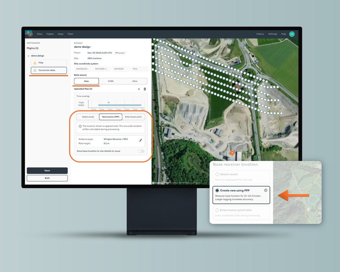
New Precise Point Positioning (PPP): absolute accuracy anywhere, without RTK or CORS
|
Precise Point Positioning (PPP) is a new feature for WingtraPRO and UNLIMITED plans powered by Trimble CenterPoint RTX.
Using WingtraGROUND or any compatible GNSS receiver as a base station, it enables globally consistent, high-precision positioning. After the flight the data is uploaded to the Wingtra software, which will apply PPP corrections automatically to obtain an accurate base location.
|
|
|
|
TBC Power Hour: Reality Capture Data Analysis Updates
|
Join the TBC Power Hour this month to explore the latest reality capture enhancements in Trimble Business Center (TBC) office software 2025.20 that maximize your field data and streamline your processing workflows.
|
- Point cloud classification: Upgraded outdoor terrestrial models offer improved accuracy to reduce manual data cleanup
- Curb and gutter workflow: Streamlined, pattern-based extraction eliminates hours of manual drafting and reduces costly rework
- ESRI Feature Service Connection: Learn how to connect, write and read features between ESRI and TBC.
- Batch ortholane processing: Process multiple mobile mapping runs simultaneously to easily handle massive infrastructure datasets
- AgileAssets integration: Transform raw pavement condition data directly into actionable asset management deliverables to extend your connected workflow
|
|
|
|
Date: Wednesday, March 25
Time: 8 AM MDT
Presenters: Mustafa Abeidi, Tavish Comrie, Jonas Collier, & Albert Oliver
|
|
|
|
|
|
Date: Thursday, March 26th
Time: 9:00 AM MDT
Presenters: Carlos Femmer & Emily Loosli
|
|
|
[Live discussion] Get insights straight from an industry professional who tested SURVEY61!
|
Join Wingtra and Carlos Femmer, Director of Geomatics and Remote Sensing at HDR, as he shares how his team tested WingtraRAY and the new SURVEY61 payload in their in-house geomatics lab ahead of real construction earthworks projects, updating I-26/I-95 in North Carolina.
Come and talk with someone who's run drone surveys on sensitive projects like the Vandenberg Space Force Base, the Golden Gate Bridge, Pearl Harbor, and the Grand Canyon.
This is your chance to learn how he evaluated accuracy, repeatability, field efficiency, and operations over people compliance on an active infrastructure site, and what gave him confidence in a GCP-free workflow.
|
|
|
|
Get to Work This Spring — Financing Starting at 1.99%
|
Spring fieldwork waits for no one — and neither should your equipment upgrades.
Whether you're looking to add a second GNSS system, upgrade your total station, or finally retire that temperamental data collector, flexible financing with rates starting at 1.99% for 12 months means you don't have to wait for the budget to catch up.
Quick approval. Competitive rates. Equipment delivered fast.
Keep your crew in the field and your operations running at full capacity all season long.
|
|
|
|
Need help applying updates or choosing equipment? Our team can assist.
|
|
|
|
{{ organization.name }} • Professional surveying equipment, service, repairs, and training.
© {% current_year %} • All rights reserved.
You are receiving this newsletter because you opted into updates. • {% unsubscribe %}
|
|
|
|
|